
Map Status Workflow 🗺️
What is the Map Status Workflow?
The Map Status Workflow is a system that a Land Legal Items follow in order that as many legal items as possible are accurately mapped.
Why would a client use the Map Status Workflow?
Clients leverage the workflow because it categorizes which legal items are eligible for automapping and which need manual intervention.
How to setup the Map Status Workflow?
The Map Status Workflow has default settings instilled as shown under Global Setup / Code Tables.
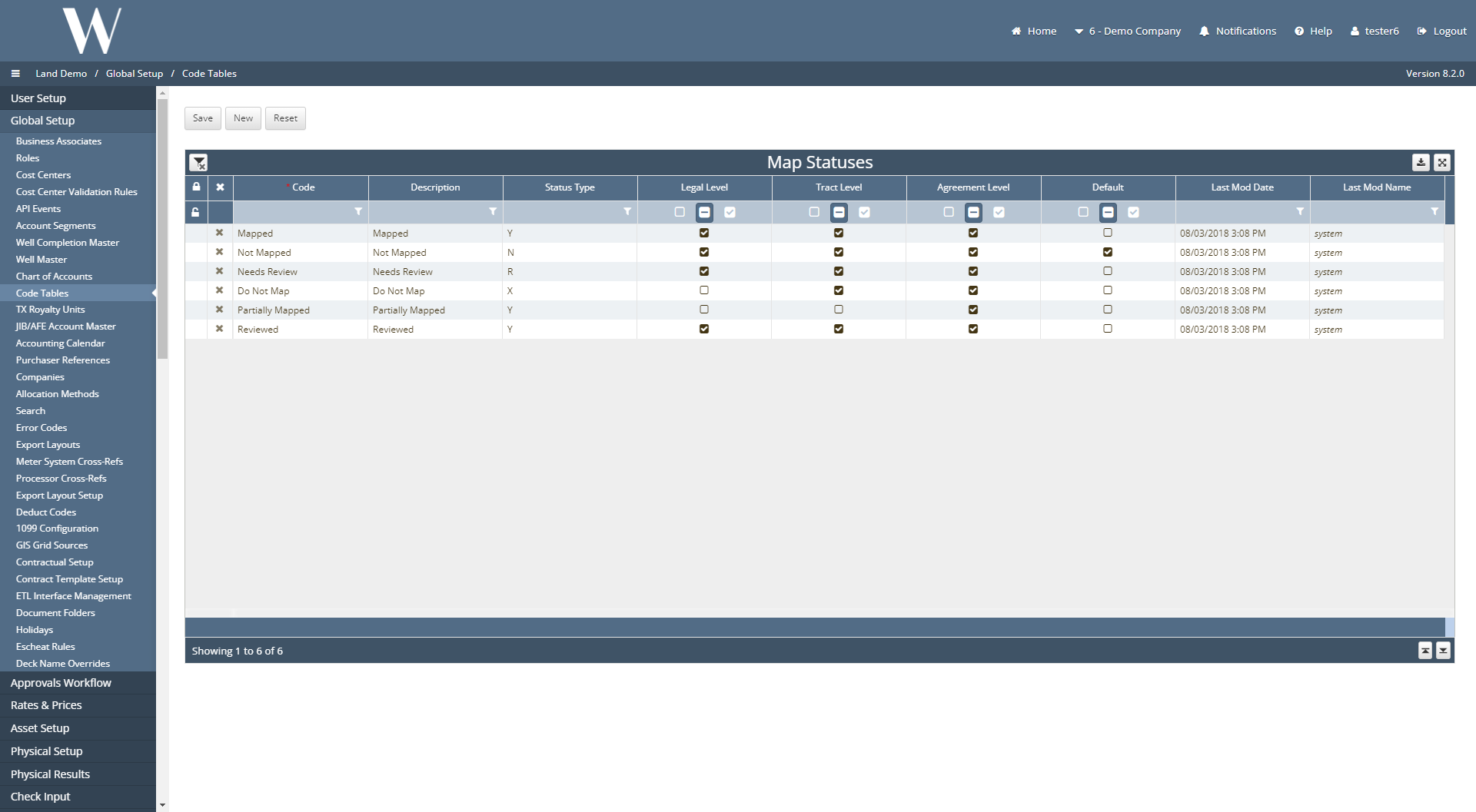
The map status value can appear at the legal, tract, and/or agreement level depending on which boxes are checked off above. By default, if a map status is not selected by a Land Analyst when creating a new legal item/tract, that legal item/tract is given a map status of Not Mapped.
These values can be updated as seen fit by the client in the application or by W Energy in the backend database under the dbo.map_statuses table.
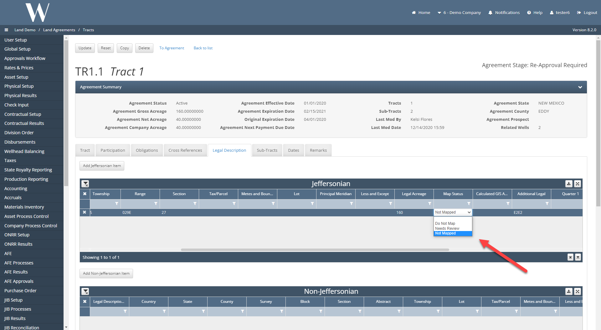
To view the map statuses at the legal item level, navigate to the Land Agreements / Tracts screen and click into an Active Tract.
Navigate to the Legal Description tab, and either find a legal item that has been created or create a new one. The map status field is a dropdown picklist with options to select.
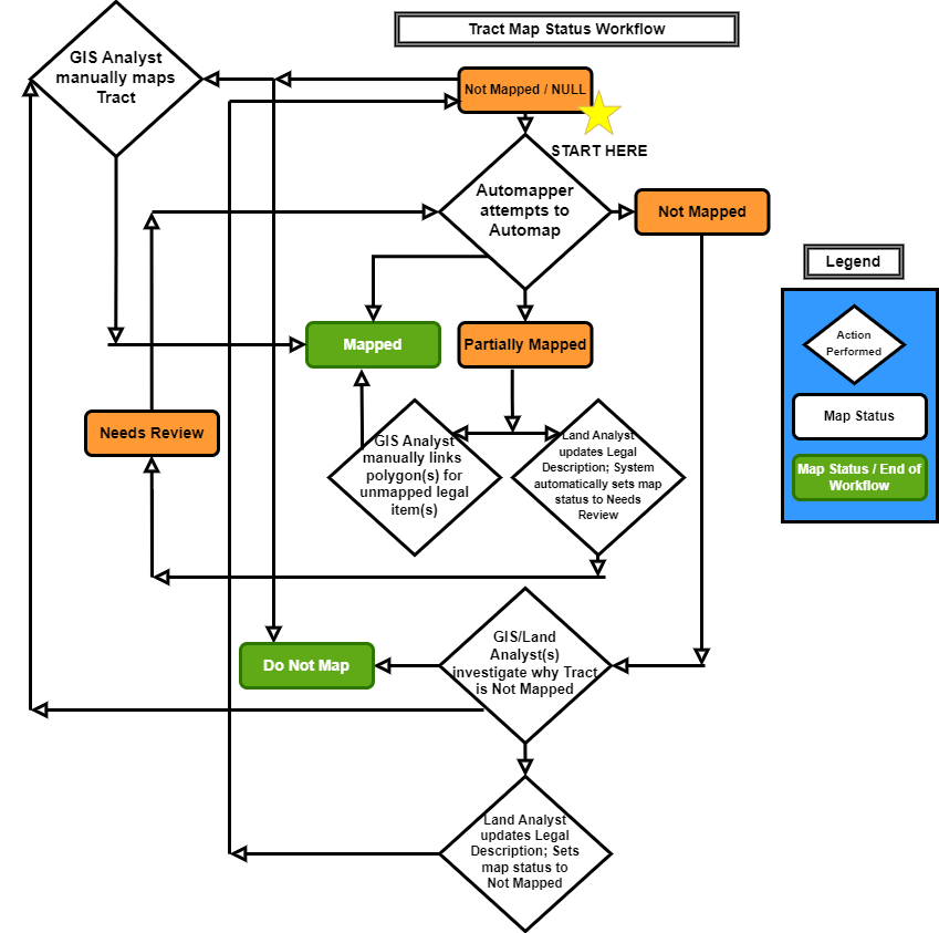
Tract Map Status Workflow
The diamonds indicate actions performed, the rectangles indicate this is a map status, and the green filling denotes this is the end of the workflow.
All tracts start under the Not Mapped map status by default as shown at the top of the diagram below (except if the tracts were loaded with a template and have a NULL map status).
The Land Analyst can set the tract to Do Not Map if desired which would be the end of the workflow.
If the tract is eligible for automapping, the Automapper will attempt to automap. For the tract to be eligible, the legal description(s) (as comprised from several fields) must be present, there cannot be a Metes & Bounds Description, and the map status must be set to Not Mapped, Needs Review, or NULL.
After the Automapper attempts to automap, if the tract is successfully mapped, then that is the end of the workflow.
If the tract remains as Not Mapped after an automap run, then the Land/GIS Analyst(s) can investigate why the tract is not mapped.
From there, the Analyst(s) can perform one of the following actions:
Set the map status to Do Not Map which would be the end of the workflow.
Update the legal description and set the map status back to Not Mapped where the Automapper will attempt to automap once more.
Manually draw and link the polygon(s) to the legal description(s).
If the tract map status is set to Partially Mapped, one of two options can follow:
The GIS Analyst manually links the polygon(s) for the unmapped legal item(s).
The Land Analyst updates the unmapped legal item’s values to make it automappable. By updating the legal item’s legal description, the map status is automatically set to Needs Review and the Automapper will attempt to automap.
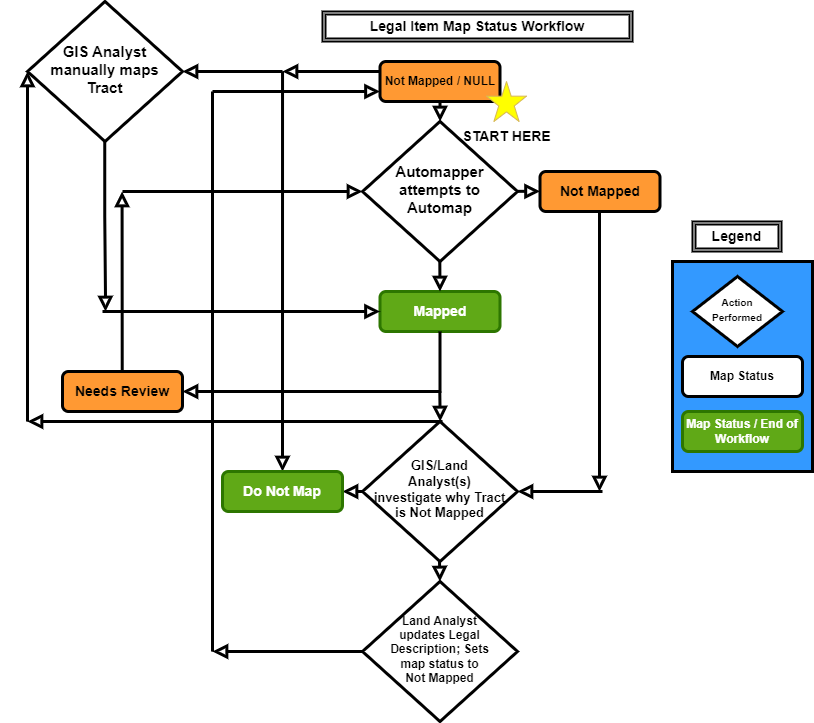
Legal Item Map Status Workflow
The legal item map status workflow is similar to the tract map status workflow but simpler since there is not a Partially Mapped map status.
All Land Legal Items start off under the Not Mapped map status by default as shown at the top of the diagram below (except if the legal items were loaded with a template and have a NULL map status).
The Land Analyst can set the legal item to Do Not Map if desired which would be the end of the workflow.
If the legal item is eligible for automapping, the Automapper will attempt to automap. For the legal item to be eligible, the legal description as comprised from several fields must be present, there cannot be a Metes & Bounds Description, and the map status must be set to Not Mapped, Needs Review, or NULL.
After the Automapper attempts to automap, if the legal item is successfully mapped, then that is the end of the workflow.
If the legal item remains as Not Mapped after an automap run, then the Land/GIS Analyst(s) can investigate why the Tract is not mapped.
From there, the Analyst(s) can perform one of the following actions:
Set the map status to Do Not Map which would be the end of the workflow.
Update the Legal Description and set the map status back to Not Mapped where the Automapper will attempt to automap once more.
Manually draw and link the polygon to the legal item.
If the mapped legal item has its legal description updated, the main application automatically updates the legal item map status from Mapped to Needs Review.
Frequently Asked Client Questions
Can the Reviewed map status be exposed? Yes. By default, the Reviewed map status is not exposed at the legal item, tract, nor agreement levels. Some clients have requested for this status to be exposed. This configuration can be changed by running the script in the referenced ticket.
WEDEVOPS-9454