
Interpreting the client_gis_config.yaml File 📁
What is the client_gis_config.yaml File?
The client_gis_config.yaml file is a config file that controls a significant amount of functionality within the GIS module.
Why would a client use the client_gis_config.yaml File?
This file is used indirectly by the client when the GIS Analyst manually links or automaps a polygon.
This file can also be directly used to show specific file paths to tables such as the automapper_log table or to display the read only GIS end user database password if the client wishes to run SQL queries.
How to View the File
Authenticate into the VDI that holds ArcGIS Desktop on it.
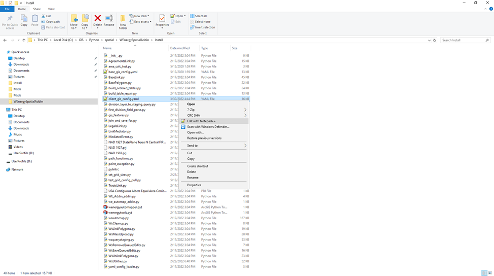
In file explorer, navigate to the file similar to the one below (this path varies slightly between environments): C:\GIS\Python\spatial\WEnergySpatialAddin\Install
To view the file, right-click on it and select Edit with Notepad++.
What Configurations Apply when using the File?
Configuration | Description |
AUTOMAPPED_MAP_STATUS | This is the map_status_id that the legal item and/or tract is updated to once the entry has been successfully automapped. A map_status_id of 1 refers to the map status of Mapped as defined in the dbo.map_statuses code table. |
DEAFULT_QUERY_STATUS_CODES | These are the map_status_ids that the Automapper attempts to automap. Map_status_ids of 2 and 3 refer to Not Mapped and Needs Review respectfully. |
MAP_ITEMS_WITH_NULL_MAP_STATUS | This indicates whether the Automapper attempts to automap legal items with the NULL map status. If the value is set to False, the Automapper will only attempt to automap the items with the Not Mapped and Needs Review map statuses. If set to True, the Automapper will attempt to automap the NULL map status in addition to the previous two mentioned. |
SKIP_AGREEMENT_TYPES | By default, this remains blank, but if the client wishes for certain Agreement Types to not be automapped, then this configuration can be set. |
SKIP_AGREEMENT_STAGES | By default, this remains blank, but if the client wishes for certain Agreement Stages to not be automapped, then this configuration can be set. |
AUTOMAP_TRUNCATE_LOG | This configuration dictates whether the automapper_log table is truncated before the Automapper writes new entries into the table. If set to True, the table is truncated each time the Automapper is called upon and right before the table takes in new entries. |
AUTOLINK_AUTOMAPPED_OUTPUT | This configuration determines if the polygon output from the Automapper is automatically Linked or if it remains unlinked and needs to be manually linked from the feature class specified in the AUTOMAP_STAGE_OUTPUT_FC yaml key. |
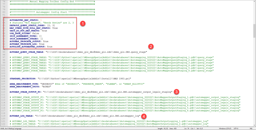
2. AUTOMAP_QUERY_STAGE_TABLE: file path that holds the query_stage table. The query_stage table is populated after the Query Staging Tool is ran which retrieves legal items that are potentially eligible for automapping from the main database. To expedite the automapping process, if the GIS Analyst does not wish for all of the legal items in this table to be attempted to be automapped, the Analyst can remove entries from this table in ArcGIS Desktop. This path can go to a table named anything, not just query_stage.
3. AUTOMAP_STAGE_OUTPUT_FC: file path that holds the automapper_output_legals_staging feature class. This is the staging feature class that the Automapper automaps to first. Once the polygons have been created in this feature class, the polygons are autolinked to the legal items and are placed into the feature class rollup. If the AUTOLINK_AUTOMAPPED_OUTPUT is not set to True, then the polygons are not autolinked. In that case, the polygons in the staging feature class can be manually linked through the Link Polygons tool. This feature class can be named anything, not just automapper_output_legals_staging.
4. AUTOMAP_LOG_TABLE: file path that holds the automapper_log table. This table can be named anything, not just ‘automapper_log’.
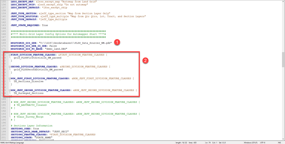
MULTIGRID_GIS_GDB: file path to the file geodatabase that holds the grid data that the Automapper automaps from.
These are the feature class grid data sets that the Automapper automaps from. The 1st division grids are the ones that do not have the Quarter Quarter Calls nor the Government Lots as fields. The 2nd division grids are the ones that do have these values.